Updating Maps Swiftly After Natural Disasters
trekandshoot/Shutterstock
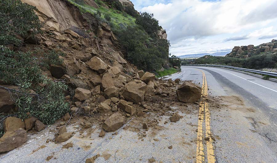
(Inside Science) -- After a natural disaster, landslides can leave roads impassable. Emergency medical responders, utility workers and residents often struggle to mobilize resources and provide relief without an accurate damage assessment of the area.
Now, geologists and computer scientists are working together to find a solution that produces an initial map of the damage in minutes.
The U.S. Geological Survey has announced a partnership with California-based artificial intelligence firm Digamma.ai to develop a way to quickly analyze satellite imagery of disaster-stricken landscapes and produce maps that can inform relief and restoration efforts.
The technology will be useful in identifying landslides in areas struck by earthquakes, hurricanes or wildfires, said Jonathan Stock, the director of the USGS Innovation Center in Menlo Park, California. They expect to develop and deploy the technology within the next several years.
“If a bunch of landslides happen, we don't really have the ability to quickly map them,” he said.
After a natural disaster, USGS personnel are sent to the area to assess the damage. Often, this requires spending hours, days and even months analyzing satellite data to find parts of the landscape that have slid or are in danger of sliding. Stock said this new partnership should dramatically cut down on the amount of time it takes to make these assessments.
While it might take an individual a year to map an area with precision and accuracy, “a machine could do it probably in a matter of minutes,” said Stock. The algorithm will analyze satellite and drone imagery as well as images scanned using LIDAR, a laser scanning technology that picks up fine details in Earth’s surface. Once the imagery is processed, USGS experts will assess its accuracy before sending the information out to the public.
There are two main types of landslides that researchers at the USGS hope to analyze: slow-moving landslides, called deep-seated landslides, and shallow landslides.
Deep-seated landslides, which occur when large sections of the mountain collapse, can be catastrophic. In many cases, these landslides are slow to slip -- sometimes inching downslope at a rate of just a few millimeters per year -- but when triggered, the results can be devastating. In 2014, the Oso landslide killed 43 people in Snohomish County, Washington. Just nine years earlier, California’s La Conchita landslide killed 10 people in Ventura County.
During smaller shallow landslides -- like those seen across much of Puerto Rico after Hurricane Maria swept across the region -- soil becomes inundated with water, weakens, and then gives way, often pulling trees and rocks with it. Because these fast-moving slides are often triggered by a specific event, it is difficult to estimate where they will occur.
There are potential drawbacks to the technology. When clouds shroud the landscape, satellites can’t spot slides. In the case of Puerto Rico, it took weeks for clouds to dissipate enough to survey Hurricane Maria’s damage from the skies. Another concern? The algorithm might have trouble identifying differences in color between soil that has failed and surrounding rock that did not fail.
Vadim Zaliva, Digamma.ai’s CEO, said the company is currently developing the machine learning algorithm that will produce the maps. Researchers from the USGS have provided a set of satellite images of known hazardous regions that will help train the software to identify potential landslides. The goal, Zaliva said, is to use artificial intelligence to weed out images where the probability that a landslide occurred is low.
The idea is to use the computer to help eliminate the images that definitely don't contain landslides to a few hundred images that might, he said. "Then let the human do the final decision."
Estelle Chaussard, a professor of geology and geophysics at State University of New York at Buffalo, is excited about the partnership.
"We need a lot more collaboration between earth sciences and computer sciences in general because a lot of the things that we're doing now with satellite data are very intensive in terms of computer time," said Chaussard.